Designing an e-consultation interface for ex-offenders
Designing a consultation fit for purpose
We considered several technologies that might be usable by people with reading and writing difficulties. These can use voice, mobile text, or graphical interfaces over the Internet. In other trials we had made it possible for people to submit views via text messages or voice mail, so that those without Internet access could at least leave their stories. You can see the results of this on the sites for The Wheel (wheel.e-consultation.org) and the Diversity consultation (http://diversity.e-consultation.org diversity.e-consultation.org]).
What we chose to explore with ex-offenders was the extent to which they might be able to use a high-graphics, low text interface.
Geographical Interface
Since the PBNI consultation was about the location of probation offices, we chose to use a geographical, map-based interface.
Google Maps (maps.google.co.uk) lets people move around a map of their area, search for locations and businesses, and get directions from one place to another. In addition, Google Maps publish an Application Programming Interface (API45) that lets developers use those maps in their own applications.
API45 helps you create your own map overlay on top of Google Maps.
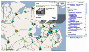
You register on the site, create a map, and then can add locations, information, pictures and comments to the map. Fiugure 1 shows the map we created for the usability test. Every current probation reporting location (whether a probation office or a reporting centre open for a few hours a day) is marked on the map (in blue), as well as the proposed new locations (in yellow). When a user clicks on a location, up pops the address, photographs of the office (if available), and any comments made about that place. They can zoom in to see the streets around the office and their homes, before entering a comment (see Figure 9.1.2). They can even get Google Maps to show them the driving route from one location to another place (see Figure 9.1.3).
Example API
CommunityWalk (www.communitywalk.com) is an example of such an application. This is currently viewable at http://www.communitywalk.com/map/5267 (All comments made during the tests have been removed to maintain their privacy.)
